Central “Red” Swing Bridge
also known as Central Bridge, the old Red Bridge
The Red Bridge name has been used with four different bridges connecting Providence and East Providence, but this is the one that “Used To Be There”
images of this Property
-
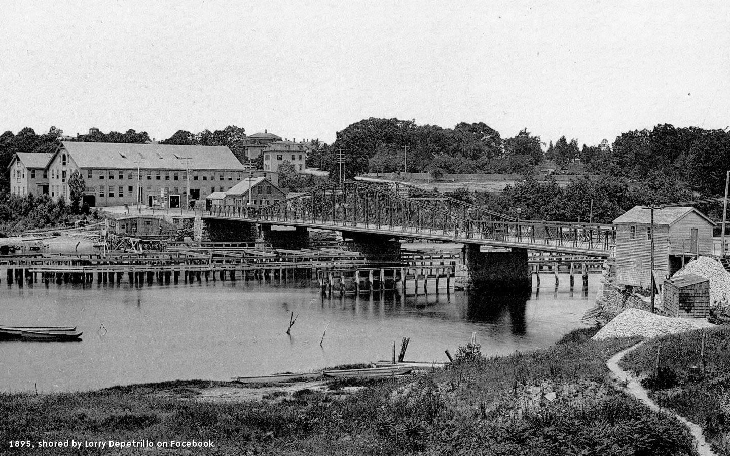
View of the Red Bridge from the eastern bank, East Providence, looking toward Providence — Photo from 1895, shared on Facebook by Larry Depetrillo -

View of the Red Bridge from the western bank, Providence, looking toward East Providence — Photo from 1895, shared on Facebook by Larry Depetrillo -

View of ironwork wign reading “1895 Central Bridge” during its modernization and widening. Streetcar rails are being added and cantilevered pedestrian walkways on either side — Photo from 1895, shared on Facebook by Larry Depetrillo -

View of the operator’s Gatehouse, western bank, Providence. Building extant today as the Waterman Grille — Photo from 1895, shared on Facebook by Larry Depetrillo -
![]()
Postcard dated 1909 from the Providence Public Library, Rhode Island Postcard Collection -
![]()
Circa 1950 view of the western approach, Providence, looking towards East Providence — Photo shared on Facebook by Ron Martin -
![]()
1956 Sanborn Maps overlaid atop a 2023 Google Map, showing the changes to the roadways when the Red Bridge was in use and the Henderson Bridge was not yet built -
![]()
1956 Sanborn Maps overlaid atop a 2023 Google Map at 60% opacity -
![]()
2023 Google Map -
![]()
Looking east northeast from the meeting of Massasoit and Waterman Avenues, over Waterfront Drive, and towards the western bank of the Seekonk River. The Gatehouse building is center, built upon the stone abutement of the former Red Bridge western side. -
![]()
Same view, closer to the edge of the embankment -
![]()
Same view, closer still from the corner of Waterman Avenue and Waterfront Drive. Notice the waterside of the Waterman Grille building, built one level below street grade into the embankment north of the stone abutment. -
![]()
Opposite view, from the second floor of the Waterman Grille looking towards the eastern bank of East Providence and the stone abutment that used to carry the east side of the bridge -
![]()
The former operator’s gatehouse building, now the Waterman Grille, view east


14 images: Press to view larger or scroll sideways to see more. Contributions from Larry Depetrillo and Ron Martin from Facebook; the Providence Public Library RI Postcard Collection; Sanborn Maps, Library of Congress, Maps Division; Google Maps
About this Property
Reason for Demolition
There are few perfect examples of the way New Englanders call things by what they used to be, and this is one of them. Named simply after the color it was painted, the original “Red Bridge” was a wooden drawbridge structure built in 1793. This was one of the shorter spans between the two banks of the Seekonk River at only 500 feet, and Moses Brown took advantage of it.
The bridge was rebuilt in wood but then later replaced by a steel “swing” structure in 1869 — meaning that the bridge swiveled on a base in the center, creating a clear path for boats to pass on both sides. Originally for horse and buggy traffic, the bridge was upgraded in 1895 with mechanical swing power and added weight capacity for streetcars, and later gasoline-powered vehicles.
Even though the iron structure may or may not have been painted red, it was officially named the “Central Bridge” — which ornamental ironwork spelled out — but most people still called it the Red Bridge, or the “new” Red Bridge.
The bridge worked well, supporting vehicles when they came about, but the bridge was low and to allow boats to pass it had to close the roadway. A frequent story that comes up is how the metal would swell in the heat, making it impossible to open or close:
It was so low that boats couldn’t pass beneath it; to let them pass, the bridge had to be swiveled. But in hot weather, the turning mechanism swelled and the bridge would lock — whether open or closed. Either the boats couldn’t go or the cars couldn’t. Traffic would back up while firefighters hosed down the bridge, to cool the metal.1
Another anecdote from the same news story has not been verified — that motorists would still try to cross the old bridge, forgetting that it was no longer there:
The bridge was closed to traffic in 1975 (to the horror of parents, children still played on it) and dismantled in 1977. In the months thereafter, motorists would sometimes forget that the bridge was no longer there, and drive right into the river. The new red bridge — the George Henderson Bridge — was built a few hundred yards upstream from the old; it has the clearance to allow boats to pass.2
With one lane in either direction and with the frustration of closing it to one type of traffic or the other, the Department of Transportation was eager to upgrade the crossing. By 1950, plans to replace the swing bridge with a taller, modern highway alternative to the north were drafted. Though less visible, the replacement bridge had its girders painted red in a nod to what people would come to inevitably call it. Officially, it was named the Henderson Bridge after the chief state highway engineer who helped design it. But you will likely still hear locals refer to it as the Red Bridge.
Current Events
The “Red Bridge” of iron which connected Waterman Street, Providence, with Waterman Avenue, East Providence, was dismantled in the mid seventies. The western Seekonk riverbank stone abutment became the base of the Gatehouse Building and the Waterman Grille. The eastern stone abutment is still accessible, along with the eastern wall along Massasoit Avenue which supported the roadway up the bank to Waterman Avenue.
History
While we were unable to find any official history from the state preservation office, the National Register, HABS, or HAER, we were able to find this detailed history from an unnamed but enthusiastic amateur. It included citations to fist party sources, therefore we think it is as official as we are going to be able to get. If anyone has any tips on better source material, please let us know.
From BostonRoads.com
Connecting the East Side with East Providence
The earliest Seekonk River crossing near the current site of the Henderson Expressway dates back to 1793, when noted New England industrialist and abolitionist Moses Brown had a bridge built to connect Waterman Street in Providence and Waterman Avenue in East Providence. Called the “Red Bridge” because of the color it was painted (and alternately called the “Central Bridge”) the bridge was a wooden truss bridge with six pile piers. There was a 24-foot-long draw span at the western end of the bridge. The original Red Bridge was destroyed by a storm in 1807.
That same year, a new Red Bridge — also made of wood and painted red — was built on the same site. It was built to nearly the same specifications as the original span, but new rubble pilings were built around the original ones as they had deteriorated significantly after the storm. In 1859, the Rhode Island General Assembly passed a law requiring all Seekonk River crossings to have a horizontal clearance of at least 38 feet. The draw on the bridge was widened in accordance with the new law, but as vessels on the Seekonk River grew larger, a new Red Bridge seemed inevitable.
On May 28, 1869, the Rhode Island General Assembly passed a law authorizing construction of a new bridge with a moveable span of at least 80 feet in the center of the river, not on the west side where the old draw span had been. Unlike the two previous bridges, which were made of wood and featured a draw span, the new 390-foot-long Red Bridge was built of iron and featured a swing span operated by hand power. The bridge was completed in 1872, and in 1895 it was upgraded with a mechanically-operated swing span, as well as strengthened to accommodate streetcar traffic.
A New Expressway Approach
In the late 1950s, the Rhode Island Department of Public Works (RIDPW) endorsed a plan for a new US 44 Expressway that would extend from I-195 (East Providence Expressway) at EXIT 3 along Gano streets in Providence, turning east over a new Seekonk River bridge 300 yards north of the existing Red Bridge, and then on new right-of-way to Taunton Avenue (US 44) in East Providence.3 The proposed route was to tie into plans being developed by the Massachusetts Department of Public Works (MassDPW) to extend the US 44 Expressway into the Bay State. The bridge itself was named in 1960 after George H. Henderson, who had served as chief engineer at the RIDPW for many years.
Through much of the 1960s, the RIDPW focused on finishing up the state’s Interstate highway network, but toward the end of that decade, the state built several key pieces of the state’s primary freeway network, of which the new “Red Bridge” was a part. The 1,903-foot-long bridge has seven spans, with its fixed center span over the navigable channel; its girders were painted red in a nod to the old “Red Bridges” that stood nearby. A viaduct approach on the east side of the span crosses a (now-abandoned) railroad right-of-way and Massasoit Avenue. The western end of the bridge approach ties into Angell and Waterman streets in Providence — the approach “exits” onto Angell Street from a “stub” highway — while the eastern expressway approach on the East Providence side has grade-separated interchanges at Massasoit Avenue and Broadway. The $7 million bridge and approach costs were completed in 1969.
According to the Rhode Island Department of Transportation (RIDOT), the Henderson Expressway carries approximately 30,000 vehicles per day (AADT). Originally built with six lanes in anticipation of freeways that never were completed on either side of the span, the RIDOT reduced roadway capacity on the bridge to four lanes, reduced the speed limit to 35 MPH, and added a bike lane. In 2008, the state said the bridge needed $50 million in repairs, primarily to fix the bridge’s deteriorated concrete supports. With the state’s finances under pressure, the RIDOT was able only to fund a $3.3 million surface repair of the bridge’s steel beams (using bolt-on steel reinforcements).
—
Captured on 24 November 2023 from http://www.bostonroads.com/roads/henderson/
Sources:
- “Executive Documents: First Session, 43rd Congress,” Government Printing Office (1874);
- “Rhode Island Roads,” Rhode Island Department of Public Works (1956);
- “A Highway Program for Rhode Island,” Rhode Island Department of Public Works (1959);
- Downtown Providence 1970, Providence City Plan Commission (1961);
- Southeastern Massachusetts Comprehensive Transportation Plan,” Massachusetts Department of Public Works (1969);
- “Planners Endorse Waterfront Proposal” by Katherine Gregg, The Providence Journal (12/06/1984);
- “Interim Ground Transportation Plan: 2010,” Rhode Island Department of Transportation (1992);
- “East Providence” by East Providence Historical Society, Arcadia Publishing (1997);
- “Providence” by Louis McGowan and Daniel Brown, Arcadia Publishing (2006);
- “DOT: Bridge Needs $50 Million in Repairs,” WJAR-TV (4/17/2008);
- Steve Alpert; Shawn DeCesari; Michael Kendricks; Sonja Shield; Alexander Svirsky.
In the News
Restaurant, offices OK’d for site on Seekonk River
by Providence Journal staff
Providence Journal | May 27, 1987
The Coastal Resources Management Council last night approved, without discussion, a $3 million, five-story restaurant and office building slated for a site on the Seekonk River at the end of Waterman Street.
Council member Donald C. Brown, a Smithfield town councilman, abstained on the vote, which included a stipulation from the council’s engineer that engineering plans which were unavailable for last night’s meeting be submitted when ready.
Harold Schein, the developer of the Richmond Square project, said excavation could begin in late July and the project will take nine months to complete.
The building will rise on the site of the former Red Bridge. It will include modifications to the road there and landscaping work. The portion of the street which was abandoned when the bridge closed will become a driveway.
Fifteen parking spaces on the site will be combined with 54 spaces Schein owns across the street for the 69 spaces needed for the project.
The project does not call for altering the river or its bank, but required council waiver of a regulation prohibiting buildings within 50 feet of coastal waters. The new building will be built with the former bridge abutment between it and the river.
The ground floor of the building will contain a restaurant. Offices will occupy the other floors.
Schein changed plans for the building after the Blackstone Park Improvement Association and the Bethany Home of Rhode Island Inc., a retirement home being built in the area of Schein’s property, requested several changes. Among them was that the bridge keeper’s house on the bank of the river not be razed.
—
“Restaurant, offices OK’d for site on Seekonk River.” Providence Journal (RI), CITY ed., sec. NEWS, 27 May 1987, pp. C-03. NewsBank: America’s News, https://infoweb.newsbank.com/apps/news/openurl?ctx_ver=z39.88-2004&rft_id=info%3Asid/infoweb.newsbank.com&svc_dat=NewsBank&req_dat=D4BD6B42F1AB4706B5E1244D477DEE03&rft_val_format=info%3Aofi/fmt%3Akev%3Amtx%3Actx&rft_dat=document_id%3Anews/15252AE0E5B98820. Accessed 24 Nov. 2023.
-
BODO, SANDOR. “LOST CIVILIZATION ROADS TO NOWHERE.” Providence Journal (RI), ALL ed., sec. MAGAZINE, 30 July 1989, pp. M-14. NewsBank: America’s News, https://infoweb.newsbank.com/apps/news/openurl?ctx_ver=z39.88-2004&rft_id=info%3Asid/infoweb.newsbank.com&svc_dat=NewsBank&req_dat=D4BD6B42F1AB4706B5E1244D477DEE03&rft_val_format=info%3Aofi/fmt%3Akev%3Amtx%3Actx&rft_dat=document_id%3Anews/1525251CEB343228. Accessed 24 Nov. 2023. ↩
-
Ibid ↩
-
Special note: The Henderson Expressway was never completed all the way to Taunton Avenue — it ends at North Broadway. But from Google Maps satellite views, one can see the wooded right of way that would have carried it over to Taunton Avenue and terminated at what is now a Park and Ride. ↩